Here in the United States, there is much excitement about the total solar eclipse that will take place on April 8, 2024. But did you know that the solar eclipse of June 15, 763 B.C. holds the key to the chronology of the Old Testament (Hebrew Bible)?
Have you ever thought about how a Study Bible can, such as, date the rule of Solomon from 970 B.C. to 930 B.C.? Or supply the dates of the rule of any other biblical king? This is a complicated topic because the Bible itself does not give such dates—typically we find “relative” dates such as “in the fourth year of his reign, King Solomon began to build the temple” (1 Kings 6:1). But when exactly is the “fourth year . . .”? Some scholars have suggested 966 B.C. But how do they know that?
It is because scholars, such as Edwin R. Thiele, have been able to link the relative chronology given in the Bible to known dates from Assyrian records (Babylonian and Egyptian sources are used as well). But how do they know the dates of Assyrian rulers and events?
A collection of limmu stelae from Asshur in the Museum of the Ancient Orient in Istanbul.
Well, I am glad you asked! It is because the Assyrians named their years after various officials, including the king. Such a person was called a limmu (don’t ask, just trust me). The Assyrians would then, in other documents, date an event (such as an invasion, a battle, the building of a temple, etc.) by the name of the limmu in which it occurred. It is fortunate that there are actually lists of limmus that can be joined to give a complete sequence from roughly 891 B.C. to 648 B.C.
But what we end up with is a sequence of limmus—giving us relative dates (“this limmu before that limmu,” etc.). How is it possible to turn this long sequence of relative dates to “absolute” dates? Well, some astronomical phenomena are tied to various limmus!
One item of unusual importance is a notice of an eclipse of the sun that took place in the month of Simanu, in the eponymy (limmu) of Bur-Sagale [name of a person]. Astronomical computation has fixed this as June 15, 763. With the year of the eponymy [limmu] of Bur–Sagale fixed at 763 B.C., the year of every other name of the complete canon can likewise be fixed. The Assyrian lists extant today provide a reliable record of the annual limmu officials from 891 to 648 B.C.; and for this period they provide reliable dates in Assyrian history. (Thiele pp. 41–42)
With this information, correlations with the Biblical text can be made, and Relative Biblical dates can be converted to what we now know as B.C. dates.
Thus, the solar eclipse on June 15, 763 B.C. has played a huge role in helping determine Biblical Chronology!
Disclaimer: this post is intended to express appreciation for all the time that scholars have put into trying to determine an accurate Biblical Chronology—it is far from a complete discussion of the many challenges met in trying to solve such a problem.
Thiele, E. R. The Mysterious Numbers of the Hebrew Kings. Revised edition. Grand Rapids, MI: Zondervan, 1965.
I thought I would share something that I have found useful, and that some of you might find useful as well—especially those who have studied ancient languages. Many of us are not naturally “gifted” in learning languages and if we don’t use what we have learned we become “rusty” in using them—if we use them at all. A Daily Dose of Hebrew is designed to help solve this problem.
Last Fall, I came across the website called a Daily Dose of Hebrew. While there, I signed up to receive a Daily Dose of Hebrew email. Each weekday the instructor, Adam Howell, translates a verse from the Hebrew Bible—parsing the verbs and offering other grammatical insights. One of the things that I like is that each Dose is only 2.5 minutes long! I have time to listen to that each morning and I have found that each “dose” helps refresh my mind as to things that I have learned in the past and it motivates me to spend a bit more time using my Hebrew Bible.
Right now Howell is going through Deuteronomy 19. Here is a sample from this past week:
In addition, Howell sends out a 7-minute video each weekend that focuses on the use of Masoretic accent marks. I had only a passing knowledge of these and have found these “sessions” useful.
If you are interested, you can give it a try by signing up at a Daily Dose of Hebrew.
Additional information from one of the Daily Dose team, Mark Futato, is listed below:
I have been teaching Hebrew to seminarians since 1988. I have always enjoyed watching students fall in love with Hebrew and the Hebrew Scriptures. Some of these students are still using the Hebrew they learned, but many are not for a variety of reasons. Daily Dose of Hebrew is designed to help you, whether rusty or not, to enjoy and benefit from the study of the Old Testament in Hebrew.
This site has three main functions:
1. The “Daily Dose” page, to which you can subscribe via email. Five days per week, subscribers are sent a link to a 2-minute video in which I talk through the grammar and theology of a single verse of the Hebrew Bible.
2. The “Learn Hebrew” page, from which you can learn Hebrew from scratch or review the basics of Hebrew grammar. These lessons are a condensation and simplification of the forty lessons in Mark Futato’s Beginning Biblical Hebrew.
3. The “Resources” page, where you will find additional electronic, online, and hardcopy resources to help you learn and use Hebrew.
Probably the most well-known structure in Jerusalem is the “Dome of the Rock.”
The Dome of the Rock was completed about A.D. 691 during the Moslem Umayyad Dynasty which was headquartered in Damascus. However recently, it has been suggested that it was built during the rule of Muawiya, sometime between AD 661 and 680 (see below). It was intended to portray the glories of Islam and to divert pilgrim traffic to Jerusalem — from Mecca and Medina.
Many believe that the Holy of Holies of both Solomon’s and later Herod’s Temples was located on top of the raised bedrock – which is now covered by the Dome.
Recently, David Padfield visited the interior of the structure and was able to take photos there. He has kindly permitted me to post some of these beautiful pictures—some of which I share here.
The “Foundation Stone” over which the structure was built has many events associated with it in Jewish, Muslim, and Christian traditions: The binding of Isaac, the place of the Holy of Holies in the Solomonic and Herodian Temples; maybe a Roman Temple, the place from which Muhammed made his night journey to the “Distant Place,” a Church Altar, etc.
View looking northeast across the top of the Foundation Stone.
The line of carvings left (west) of the center of the image are the foundations of steps that were carved out during the Crusader Era (ca. 1099-1187). At that time, the “Dome of the Rock” was used as a church and the steps ascended to the high altar that was constructed on the top of the rock. Ritmeyer, “The Quest,” suggests that much of the quarrying of the rock took place during this period.
The base of the circular Dome is visible in the upper portion of the image. It is supported by four large piers (2 are visible) with three columns between each of them. The piers are covered with marble slabs. A wooden fence surrounds, partially visible in the lower portion of the image, surrounds and protects the rock.
View looking down on the sacred stone, often called “The Foundation Stone. North is at the bottom, west to the right, south on the top, and east to the left.
The photo was taken from the Dome sometime between 1900 and 1920 and is part of the Matson Collection. Notice that around the periphery, there is grating between the columns. This grating was put in place during the time that the Crusaders(!) controlled Jerusalem (1099-1187, 1229-1244). It is now in the Islamic Museum located in the southwest corner of the Haram.
If Leen Ritmeyer’s reconstructions are correct, then this rock was where the Holy of Holies was located during the First and Second Temple Periods. The back of the Holy of Holies was on the west (right) where the rock scarp is clearly delineated.
View looking up at the interior of the Dome that is over the Foundation Stone. JMO (p. 95) wrote: “Damage to the dome meant that the mosaics of the drum needed restoration at least six times, but experts agree that the original designs were retained. All the other mosaics needed only light repairs.”
The patterns of the mosaics include stylize vegetation, and jewellery. Many of the mosaic cubes are actually gold set at various angles to enhance the beauty of the scene.
Three Arabic inscriptions are visible. One is in a thin strip at the base of the Dome just above the gold-decorated base. Above the windows- the middle inscription is visible and closer to the central point of the dome the inner inscription is visible. Obviously, Arabic calligraphy is an art form.
Notice the windows that let light into the structure. The marble-clad arches above the columns that support the dome are visible in the photo.
IMHO — a dizzying display of color, textures, and building materials.
The inscription attributes the construction of the building to the Abbasid caliph al-Mamun, but the date on the inscription indicates that it was constructed earlier by the Umayyad calif Abd al-Malik (ca. A.D. 691-692). However, recent researchers have suggested that the building was constructed even earlier(!)—by the first Umayyad caliph Muawiyad (r. 661-680) (Artifax (Autumn 2023) citing an article in National Geographic, September, 2023)!
View looking north at the Entrance to the “Well of the Souls” (aka “The Cave”) that is located under the pointed archway in the center of the image. The woman in blue, with a khaki vest, is a “Guard of al-Aqsa Mosque.” Sixteen stairs lead down into the cave. Behind the glass in the center, the Foundation Stone is visible.
On the left (west) side of the image, the 5-6 foot wooden screen that protects the rock is visible. On the far left is a tall “cabinet” with a pointed dome—only the top of it is visible. Inside of it Muslims believe is some hair from the prophet Muhammad and a stone that contains his footprint.
The cave chamber itself is about 20 feet square, and the height of the ceiling varies between 5 to 8 feet. There is a shaft about 1.5 ft. in diameter that penetrates the 5 ft. 7 in. thickness of the rock above. The prayer “niches” in the chamber that are dedicated to Dawud (David), Suleiman (Solomon), Ibrahim (Abraham), and Khidr-Elijah.
For additional information on the cave, see conveniently — Well of Souls. (2023, November 8) in Wikipedia.
View looking south at the prayer niche (mihrab) that is dedicated to Suleiman (Solomon) in the “Well of Souls.” It is located to the east of the staircase (partially visible on the right) that leads down into the cavern. The Mihrab points the faithful in the direction of Mecca as they pray.
The Mihrab is composed of a trefoil arch that is supported by miniature marble twisted-rope columns (Wikipedia). It may be the oldest mihrab in the world — dating to the 9th or maybe even the 7th century—from when the Dome was originally constructed. Note also, the patterns on the carpet that mark off where the faithful pray.
View looking north at the eastern, main, ambulatory. There are three concentric circular “rows” of columns that encircle the Foundation Stone. This is the main ambulatory that runs without obstruction around the whole of the octagonal-shaped building. The inner ambulatory (not visible) is left of the left columns between the rock and those columns, and the outer, to the right of the columns on the right. Since there are only women in the photo, is this a place where they typically gather for study—see the group on the left?
Just beyond the women on the left is a column, and to the left of that is the Foundation Stone (not visible). If Leen Ritmeyer’s placement of the Holy of Holies on the Foundation Stone is correct, then this would be the area where the “Holy Place” would have been—the place where the incense altar, the candelabra, and the table with showbread were located.
To see additional images and commentary on both the Interior and Exterior of the Dome of the Rock See Here.
Photo from the top of the Dome looking down: The photo is from the Matson Collections, Public Domain, titled “The rock of the Dome of the Rock Corrected” downloaded from Wikipedia. Dome of the Rock. (2023, October 26). In Wikipedia. https://en.wikipedia.org/wiki/Dome_of_the_Rock
Much information in this blog is fromThe Quest, by Leen Ritmeyer who discusses in-depth the whole of the Temple Mount (Haram esh-Sharif). Ritmeyer, Leen. The Quest: Revealing the Temple Mount in Jerusalem. Jerusalem: Carta, 2006. See also Ritmeyer, Leen and Kathleen. Jerusalem — The Temple Mount — A Carta Guide Book. Jerusalem: Carta, 2015.
JMO = Murphy-O’Connor, Jerome. The Holy Land: An Oxford Archaeological Guide From Earliest Times to 1700. Revised and expanded Fifth ed. Oxford: Oxford University Press, 2008.
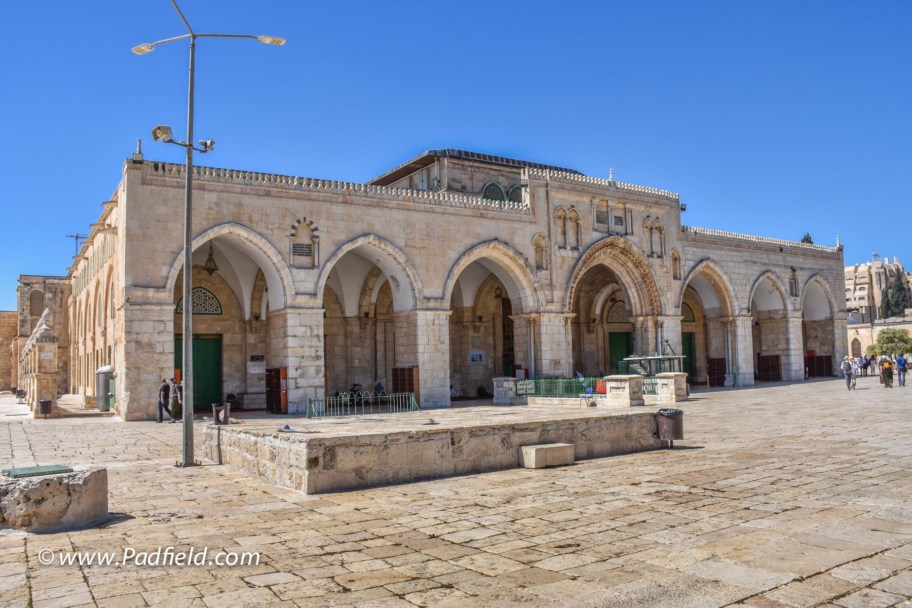
Many of the readers of this blog have been to Jerusalem and have visited the Haram esh-Sharif (aka The Temple Mount). In recent years it has been difficult to gain access to the interior of the el-Aqsa Mosque that is located on the south edge of the Haram area—let alone take good photos of the interior.
The el-Aqsa Mosque — looking south at the entrance. This is the main mosque in Jerusalem.
Last year a friend of mine, David Padfield, gained permission to enter the structure and to take photos of the interior. He has graciously allowed me to post a selection of those images on http://www.HolylandPhotos.org.
The el-Aqsa Mosque is the third holiest site in Islam – after Mecca and Medina. Its name means “the distant place,” and it is believed that Mohammed made a “night journey” to this place.
Caliph Walid (A.D. 709–715) built the first mosque. It is built over a large number of subterranean arches, not on bedrock, and thus has been destroyed by earthquakes and rebuilt many times (the most recent in 1927). During the Crusader Period (A.D. 1099-1187) it served briefly as the palace for the Crusader kings of Jerusalem, but then became the headquarters of the Knights Templar until the Crusaders were expelled from Jerusalem—when it was returned to its original function as a mosque.
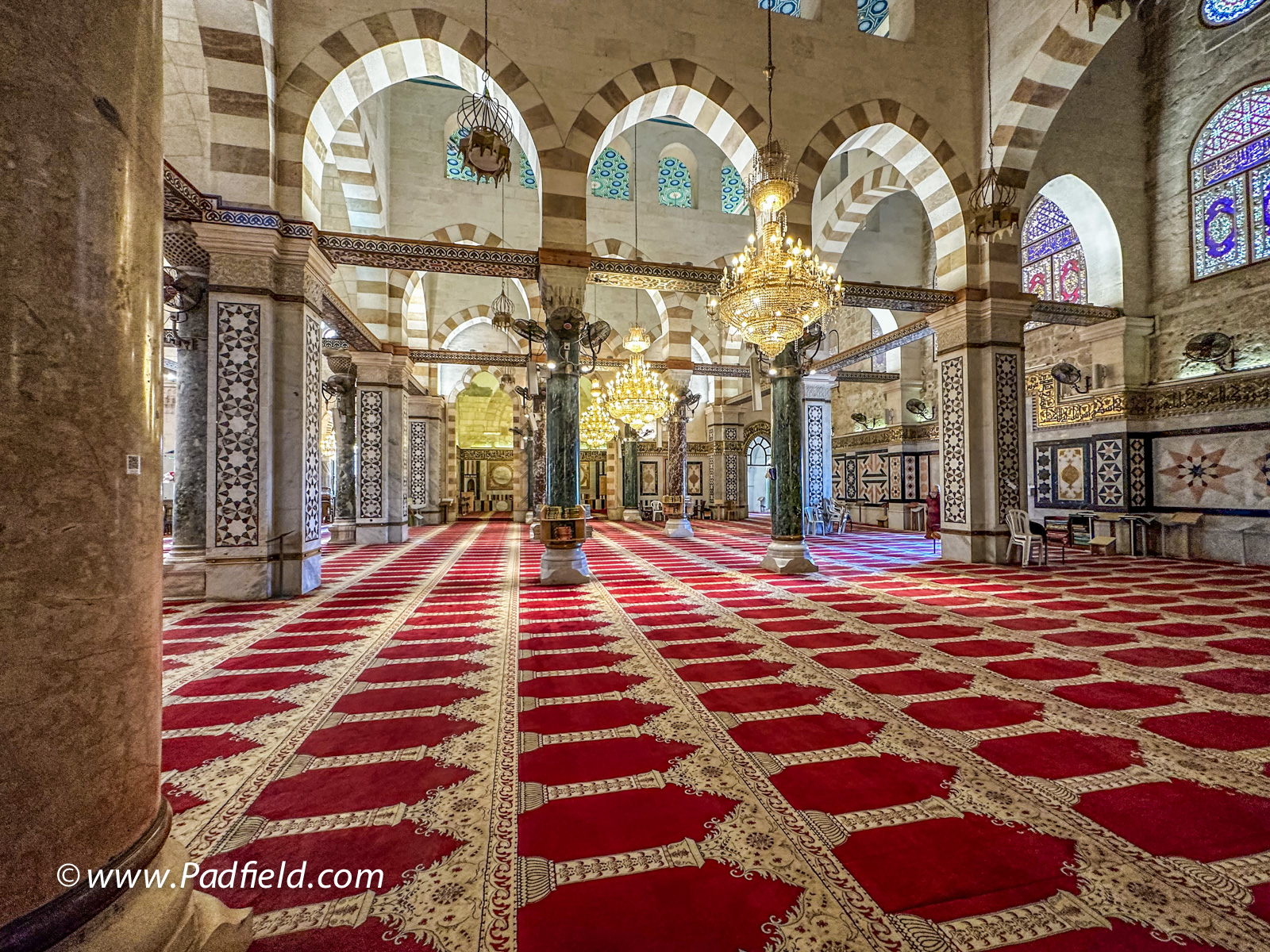
View looking south inside the al-Aqsa Mosque down the “nave” toward the area where the mihrab and minbar are located.
On the left (east) the three eastern aisles are visible among the columns. On the right (west) one of the three aisles is visible between the row of columns and the row of brick pillars. The marble columns were donated by Mussolini. On the floor, notice all of the marked-out spaces on the carpet where individuals pray facing Mecca. The ceiling was a gift of King Farouk of Egypt during the last reconstruction (1938-1942).
View looking south inside the el-Aqsa Mosque at the southern wall of the structure.
In the center of the image is the semi-circular Mihrab that directs the attention of the worshipers towards Mecca. To the right of that, is the Minbar, the “pulpit” from which “sermons” are given. Above the Mihrab are beautiful windows of a variety of colors. The base of the central dome is visible just above the center of the image.
A detailed view of the southern wall of the el-Aqsa.
Note especially the semi-circular Mihrab that points the attention of the worshipers towards Mecca. To the right of that is the Minbar, the “pulpit” from which “sermons” are given. In 1187, when Salah edh-Dhin restored the building he donated a beautifully carved Minbar. This minbar was destroyed by a fire set by an unbalanced Australian in 1969 and was replaced by the current structure. The wood carvings on this minbar are also very beautiful!
View looking up at the central Dome that is located at the south end of the Mosque, over the area where the Mihrab and Minbar are located. Note the Arabic inscriptions above the windows of the Dome.View looking east along the southern wall of the al-Aqsa Mosque.
Notice the marble paneling on the walls, the marble columns, the arches, and the colorful windows. In the foreground is where the central “nave” of the mosque is located, and the Mihrab and Minbar are located on the right side of the image (not visible in this photo). On the left (east) the three eastern aisles are visible among the columns. On the right (west) one of the three aisles is visible between the row of columns and the row of brick pillars. The marble columns were donated by Mussolini.
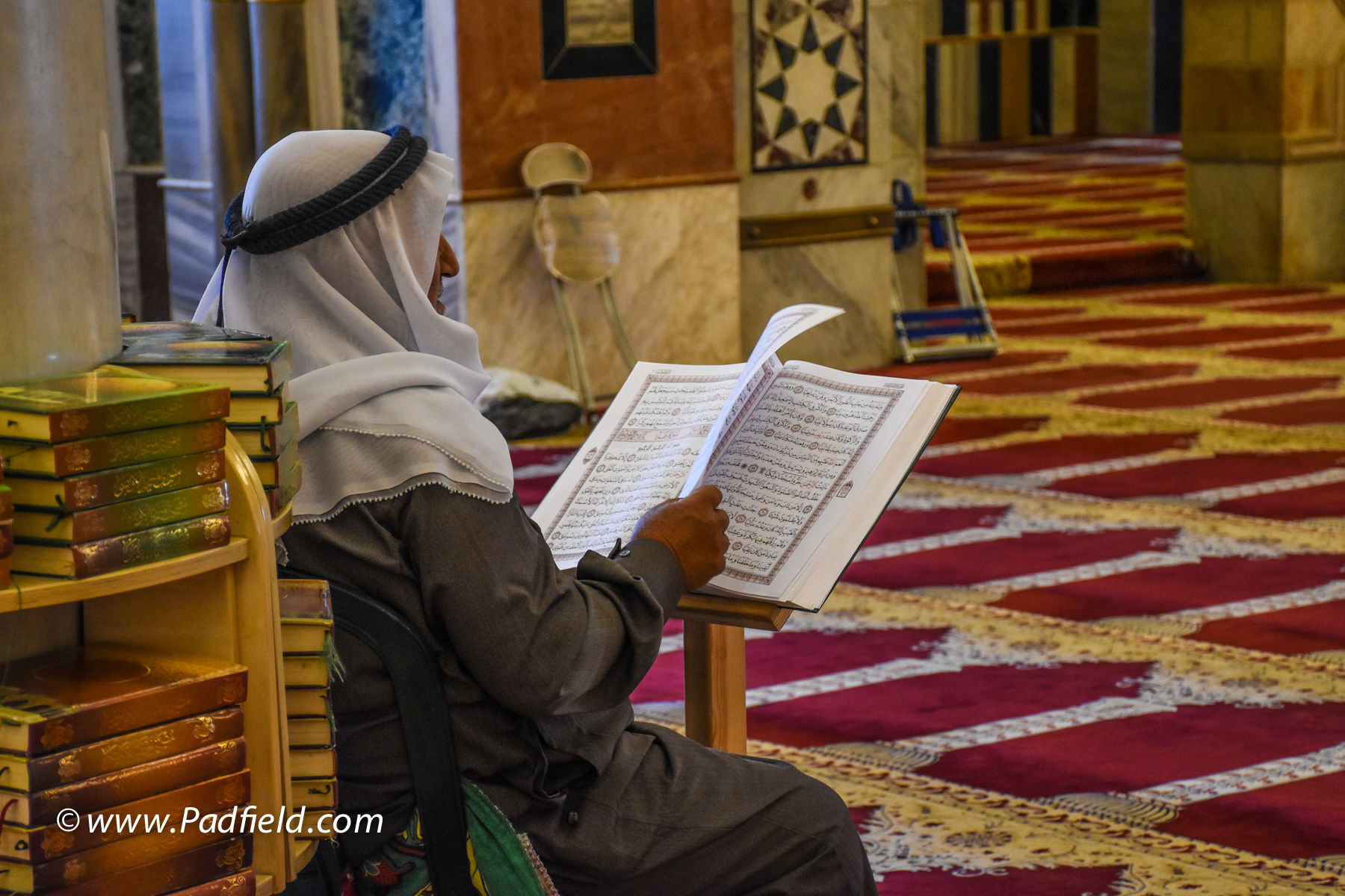
A Palestinian reading the Koran in the al-Aqsa Mosque
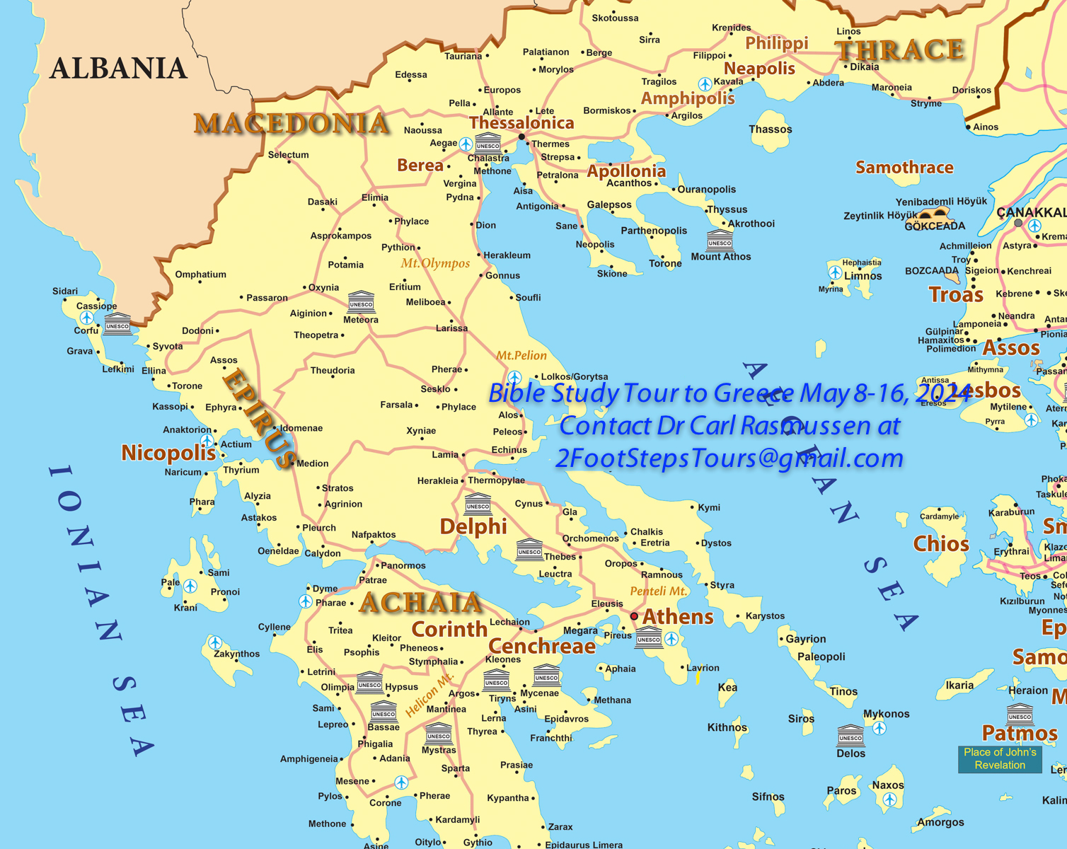
Although travel to Israel is not possible right now, we are offering two comprehensive Bible Study Tours — one to Turkey followed by one to Greece in the spring of 2024. You are invited to join us on one or both of these “once in a lifetime” trips. As many of you already know, there is nothing like studying the Bible in the lands of the Bible!
On our Bible Study Tour in Turkey (April 25–May 9, 2024), we will begin in Istanbul, visiting the Hagia Sophia and the world-class Archaeology Museum. From Istanbul, we will fly to Antioch-on-the-Orontes River, the third-largest city in Paul’s day, where believers were first called “Christians” and Paul began all three missionary journeys. We will visit Seleucia, the port where the first journey set sail (Acts 13:4), Tarsus (the home of Paul), Derbe, Lystra, Iconium, and Pisidian Antioch—places not usually visited by tours but all of which are of biblical importance. After stopping for two nights in the Mediterranian city of Antalya we will travel to Colossae, and then begin our exploration of all of the Seven Churches of Revelation—with many stops (email me for the complete itinerary).
On our Bible Study Tour of Greece (May 8–16, 2024), we will begin in Thessaloniki in northern Greece. We will begin touring with a day trip to Philippi, where the “Good News” was first preached in Europe. As we motor towards Athens we will be stopping along the way at Berea, Vergina, Meteora, and Delphi—with overnights near Meteora and Delphi. In Athens, we will visit the Acropolis, the Areopagus (“Mars Hill”), and the new Acropolis Museum. We will take a day trip to Corinth and Cenchrea. Email Dr. Rasmussen for an Itinerary and Details (2Foot.Steps.Tours+TGB@gmail.com).
Dhahr Mirzbaneh is a site located about 16 mi. northeast of Jerusalem. The hillsides in the area are covered with tombs from the Middle Bronze I Age (2200-2000 B.C.).
Cut Away of MB I Tombs During Construction of the “Alon Road”
View looking northwest. When the “Alon Road” was being constructed in the 1970’s, the construction workers cut through the hillside of Dhahr Mirzbaneh exposing a side, “cut-away,” view of a number of Middle Bronze I (2200-2000 B.C.) tombs. Some scholars place the migration of Abram from Ur to the Land of Canaan during this period.
A perfect “cut-away” view of such a tomb is visible on the left side of the image. The shaded semi-circular area is a tomb chamber, and to its left the “cut-away” outline of a vertical shaft (partially filled with rubble) is visible.
On the right side of the image more exposed tomb chambers are visible.
Detail of MB I (2200–2000 BC) Tomb
View of a MB I (2200-2000 B.C.) tomb which was sliced in half by road building activity.
A typical MB I tomb consisted of a vertical shaft, 4 to 9 ft. [1.2 to 3 m.] deep, cut into the rock. At the bottom of the shaft one or more chambers radiated from it. Usually only one person was placed in each chamber.
To the left of the leg of the man, the shaded arched outline of a burial chamber is clearly visible – it had an arched top and a flat horizontal floor. To the left of the chamber, partly shaded, is the outline of the vertical shaft, which led down from the surface to the burial chamber. This shaft is partly filled with rubble.
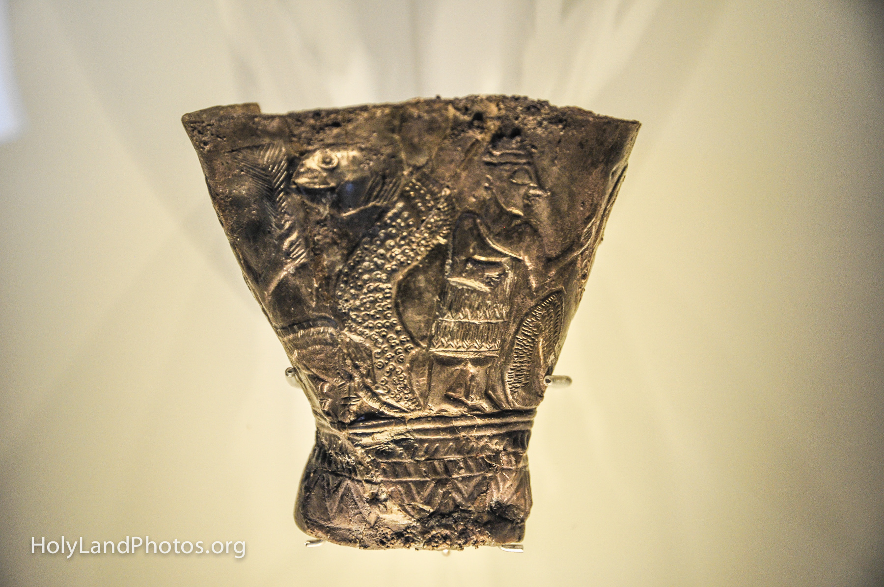
Ein Samiya Cup from MB I (2200-2000 B.C.)
View of the silver cup/goblet that was found in one of the MB I (2200–2000 B.C.) at Ein Samiya (Dhahr Mirzbaneh). It is a very unique find in that the grave goods found in these tombs are usually few and simple (beads, knives, etc.).
The silver goblet is carved with a mythological scene from possibly the epic of Enuma Elish. The human figure is actually bounded on each side by dragons/snakes. The one on the left of the cup is clearly visible. Y. Yadin suggested that the scene depicts the victory of Marduk over Tiamat. Note the dress of the human. The goblet was probably made in Syria and was an heirloom.
The goblet is on display in the Israel Museum, Jerusalem.
To view more images of Dhahr Mirzbaneh, and a map, Click Here.
QUICK — what was the Lycian League? Not many of us know, but Alexander Hamilton and James Madison knew! Yes, the “Lycian Confederation” is mentioned four times in the Federalist Papers that were produced between 1787–1788 (#9, 16, 45). Over 2,000 years ago it met in Patara—the same place where Paul and Luke changed ships on their way to Jerusalem (Acts 21:1-3).
View of the exterior of the reconstructed Council Chamber (Bouleuterion) at Patara January 2014 — Click on Image to Enlarge/Download
So what was the Lycian Confederation/League? First, Lycia was/is a geopolitical region located along the Mediterranean Coast of modern Turkey, often called the Turquoise Coast because of its beauty! (see map below) The 23 cities that made up the Confederation/League were located along the Mediterranean coast or in the nearby rugged Taurus Mountains (but the number of cities varied from time to time).
View of the interior of the Council House at Patara Click on Image to Enlarge/Download
The Lycian Confederation is the first known republic union in history! One of the features of this Confederation is that they committed themselves to be governed by a central assembly (Greek: synedrion) that they themselves elected. However, in fairness, the larger cities were allotted more representatives than the smaller ones. Large cities such as Xanthos, Patara, Myra, Pinara, Tlos, and Olympos were allotted three representatives each (the maximum allowed).
The Lycian Confederation met at Patara—almost certainly in the Bouleuterion pictured above. It was thus here (at the out-of-the-way site of Patara) that proportional representative government first got its start. And, it was not until the founding of the United States (2,000 years later!!) that this concept was revived in the US House of Representatives (note the semi-circular seating arrangement of its chamber)!!
The Rugged Taurus Mountains and the Mediterranean Coast of Lycia The cities of the Lycian Confederation were located along the coast or in the mountains Click on Image to Enlarge and/or Download
The league itself may go back to around 205 B.C. This early form of the league would have had the power to decide questions of war, peace, and alliances. In 168 B.C., while still under Roman control, the Romans allowed these cities to still assemble together to govern themselves as a unit—but the power to decide questions of war, peace, and alliances were now Rome’s prerogative.
This body elected persons who administered the Lycian League for a year at a time. The council elected judges. Voted proportional taxes. A league court decided disputes between the cities.
I have posted 5 photos of this historic meeting place on my web site,
both before and after it was excavated/reconstructed.
For a great summary article on the Lycian League and Patara see the article in Saudi Aramco World 2007.
In March 2013, Francesco D’Andria, professor of classic archaeology at the University of Salento and excavator at Hierapolis announced that he had excavated the, well–known to ancient authors, Plutonium at Hierapolis—which was thought to be the gate to the Underworld. For many years since then, as we visited Hierapolis (Colossians 4:13) I would look longingly into the excavated area which was firmly closed off by a secure fence!@#$#@! They even had the walkways and signage in place—but no entry was allowed.
This past spring (2023) I was very excited to find that the Plutonium was now open!
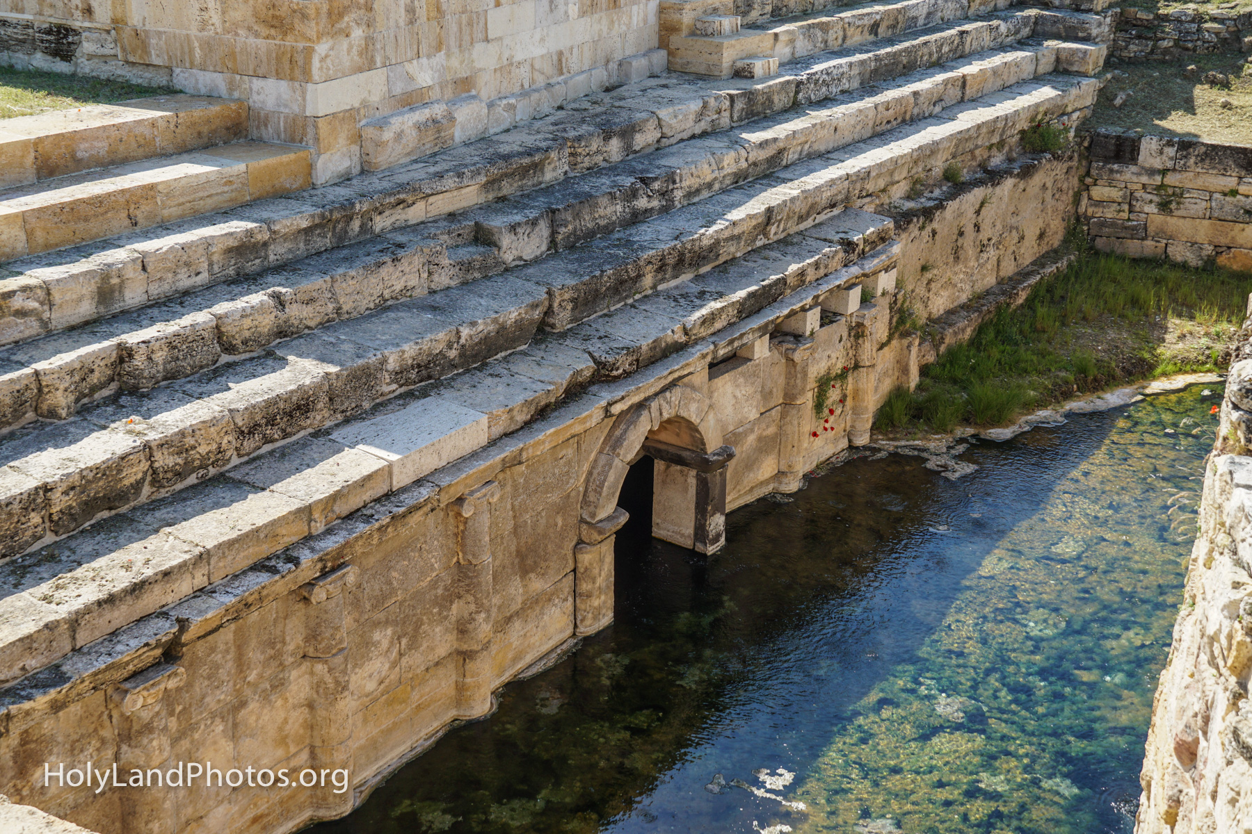
Looking south at the excavated, and rebuilt, remains of the “New Plutonium” at Hierapolis.
Note the rectangular pool that today is filled with thermal water. On the left (east) wall of the pool, there is an arched opening. According to the excavator, noxious gases were (are?) emitted from this opening—and this was the “gate to hades“! This arched way is flanked on both sides by a “colonnade” of pilasters in the Ionic order.
The pool was surrounded on three sides by stone benches on which worshipers would sit and observe the rituals taking place around and below them. The benches are well preserved in the foreground (north), and on the left (east), but are largely missing on the far side (south) of the pool.
Above the pool, on the left, is a replica of the large statue of Pluto and two serpents, that was found here.
Entrance to the Underworld.
View looking down at the east wall where there is an arched opening that is thought to lead to the underworld!
According to ancient authors, rites were performed at the entrance of this cave. Bulls were sacrificed by causing them to be asphyxiated by the fumes from the cave. If thermal waters also flowed from this cave, then there must have been some sort of raised platform on which the rites were performed—that is, above the water.
Various sculptures symbolic of the Underworld were found in the vicinity, including a colossal statue of Pluto (12 feet tall, see replica here), two statues of serpents, and a statue of Cerberus, the three-headed dog that guarded the entrance to the Underworld.
Plutonium from the south.
In the center of the photo is a shallow rectangular pool. At the far end is a door through which the bulls were led into this space to be sacrificed. In ancient times there probably was a raised platform upon which the sacrificial rites took place.
The entrance to the chamber from which the lethal fumes of Carbon Dioxide are/were emitted is on the right (east) side of the pool—visible in this image. The animals were overcome by the fumes and slaughtered.
Above the rectangular space, on the right (east) and to the north are two of the three sets of benches upon which around 800 worshipers could sit and observe the rituals taking place below and around them.
In the upper right quadrant of the photo is a full-scale reproduction of a statue of Pluto, the god of the Underworld, and two snakes. These were among other statues found in the area.
A platform is on the left (west) side of the image, above the wall that outlines the pool. The excavator says that two pools of freshwater and a round structure (tholos) were constructed there. The meager outlines of the foundations of these are barely visible.
Hades/Pluto.
This is a view of a seated statue of the god of the Underworld (Greek: Hades; Latin: Pluto).
Below him, to our left, is a statue of Cerberus, the dog that guards the entrance/exit to the Underworld— and which prevents inhabitants from leaving the realm. Often, but not always, he has multiple heads—usually three. Here he has only one head, but note the snake(s) wrapped around his body and his paws.
According to the sign in the museum, the statue dates to the second century A.D. and was found in the theater of Hierapolis.
It looks very much like it was the basis on which the replica statue that towers over the Plutonium was constructed.
For a very vivid description of the rites that took place at the Plutonium see chapters 3 and 4 in Stanley, Christopher D., A Bull for Pluto— Book Two in the A Slave’s Story Trilogy. Second Edition. Buffalo, New York: NFB Publishing, 2020. Stanley’s novels are masterfully done and are based upon the latest archaeological finds (including this one) and ancient literature.
For additional photos of the new (and old) Plutonium see Here.
On a recent visit to Caesarea Maritima (April 2023), we noticed that the local authorities were working on an area at the western end of the Peristye Courtyard of the Promontory Palace.
The Peristyle Courtyard of the Promontory Palace at Caesarea. The area being worked on is on this image’s right (east) side.
When visiting Caesarea in 2023 we had a chance to see this area while it was being excavated.
The cistern/prison being excavated in 2014.
In the literature about Caesarea, there was an emphasis on the interpretation that this area was a large cistern.
The sign at the site now says:
The undergreound structure was originally used as a T-shaped cistern, however after the Herodian period it was converted into a prison. A courthouse was built to the North of which, [is] above ground. The following, inscdribed in mud by a female prisoner, was found in the cistern: “Lord [Jesus] help Procopius.” Researchers [now] believe that this may be where Paul was tried and imprisoned.” [ca. AD 57-59). Acts 24:27 When two years had passed, Felix was succeeded by Porcius Festus, but because Felix wanted to grant a favor to the Jews, he left Paul in prison. The sign also notes that Rabbi Akiva may have been kept here as well. He was imprisoned for over three years at Caesarea during the Second Revolt (ca. CE 132-135). Upon completion of the work, the public will be allowed into the prison to see the remnants.
From the sign at the construction site at Caesarea
Work underway in April 2023 on the cistern turned prison under the Peristyle Courtyard of the Promontory Palace at Caesarea.
Since Paul had already pulled the “I am a Roman Citizen” card in Jerusalem, before being transferred to Caesarea (Acts 21:39; 22:25-29; 23:27), the Roman officials, Felix and Festus, knew this. I find it difficult to believe that a Roman Citizen who had not been convicted of a crime would have been kept in an underground space such as this for an extended period of time.
We will be visiting Caesarea Maritima, as well as many other sites, on our 13-day Exploring Israel from Dan to Beersheba — October 6-18, 2023 — see Here.
Greetings! From October 15 to 27, 2024 Mary and I will be leading a 13-day trip to Israel during which time we will Explore Biblical Israel from Dan in the north to Beersheba in the south.
Hiking into el-Araj — Biblical Bethsaida on the northeastern shore of the Sea of Galilee
This trip not only includes Jerusalem and sites associated with the ministry of Jesus around the Sea of Galilee, but also some not-so-frequently visited sites such as Arad, Beersheba, Lachish (second most important Judean city after Jerusalem), Azekah (David and Goliath), Beth Shemesh (Samson), Shiloh (Tabernacle and Ark of Covenant), Mount Gerizim (Samaritan Temple), and Samaria (capital city of Ahab and Jezebel and others).
The excavator of Biblical Chorazin, Achia Cohen-Tavor, speaks to our group at Chorazin.
I will be giving mini-lectures along the way both on the bus and on the sites, drawing from my studies. I have spent 16 years of my adult life living in, and guiding, academic groups in Israel, Jordan, Greece, and Turkey (including living, teaching, and guiding in Jerusalem for 7 years).
Reading scripture at Azekah, high above the Valley of Elah—where David fought Goliath
Tour Dates and Cost: October 15 — 27, 2024. Cost: $4,990 per person in Double Occupancy; add $1,365 Single Room supplement; Includes airfare from New York to Tel Aviv and return. Other departure cities are possible at extra cost.
You are invited to join us! Carl and Mary Rasmussen
We will be led by Master Guide, and my friend, Ofer Drori. This specially planned itinerary is based upon my experience of leading/guiding/teaching over 100 groups in Israel and is structured to include as many important biblical sites as possible as we study the Bible in the Land of the Bible.